
by Oliver Longenecker
How often do you check the weather? Everyday? Occasionally? When you’re figuring out what outfit to wear? To see if a practice or game will get canceled? Well, the vast majority of people don’t check it at all. Now, depending on where you live, you may not need to; maybe it’s always sunny and warm. Unfortunately, the weather is never always “normal” here in Kentucky, and this upcoming winter season will be no different. So, what will the weather be like this winter? Based on recent data, weather patterns, a neutral “La Nina” pattern, and historical data, here is how I think our winter season will look.
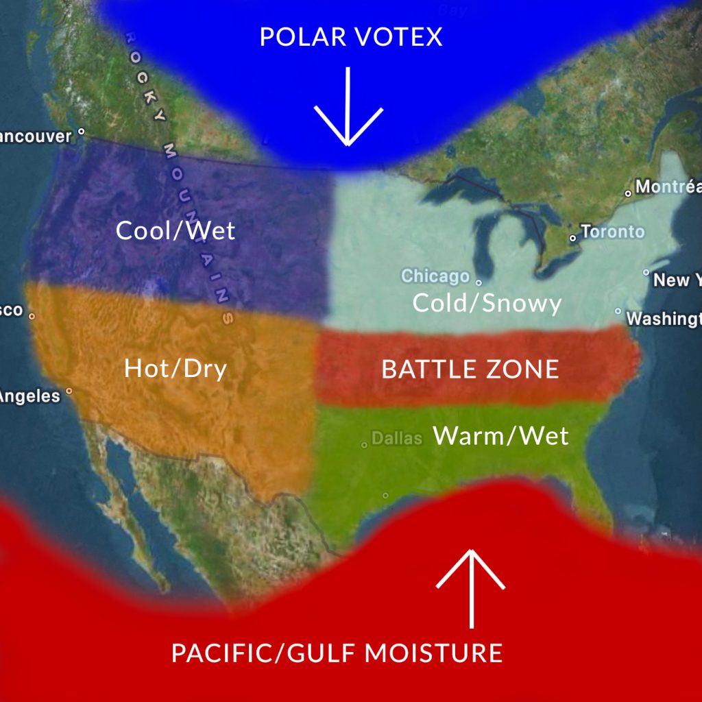
Here’s a graph of how I predict our winter will look across the U.S.
The Northwest will see cooler than average temperatures, and an increase in precipitation.
The Southwest will see warmer than average temperatures, and an increase in dry/drought conditions.
The Northeast and Upper Mid-West will experience much colder temperatures and an increase in snow and ice.
The Southeast will experience warmer than average temperatures, along with increased precipitation.
Wait, there’s one more region, the “Battlezone.” This area is our roller coaster. This area, which consists of the Ohio Valley and Mid-Mississippi River Valley, includes the states of Kentucky, Tennessee, Virginia, West Virginia, North Carolina, Missouri, Arkansas, and Oklahoma. But why this area? Why is it the Battlezone? Well, to put it simply, this area will act as the boundary between the Polar Vortex to the North, and the Pacific/Gulf moisture to the South. This winter, we expect parts of the Polar Vortex to break through and bring cold/arctic temperatures to the U.S. To the South, due to the neutral “La Nina” pattern in the Pacific, warm and moist air will park itself over the mid to lower 48. It’s where these two air masses meet, is where the battle takes place. What do I mean by battle? More intense severe weather, tornadoes, damaging winds, and flash flooding.
Traditionally, in past winter seasons, we’ve seen both little, and large dips in the “Jet Stream” where cold air dips south, while warm/gulf air is pulled to the North, and where that boundary is, where we see severe weather and snow/ice storms.
This winter, that boundary, instead of being in the form of what’s traditionally known as a vertically tilted “Trough,” will be slightly more horizontal, acting more like a wall. However, there could be some moments where the dip in the jet stream could be powerful enough to become a negatively tilted trough, meaning more powerful storms.


A traditional “Negatively Tilted Trough” boundary; The “Horizontal Trough” boundary
Now, y’all are probably wondering, does this mean more storms? Well, yes, quite a few actually. While we will see an increase in severe weather across Kentucky, we’ll also see an increase in winter weather. Yes, that means snow and ice. Due to the way this boundary will be formed, some days could be cold with temps dipping down as low as into the teens” while other days it could be sunny and fifty-sixty degrees which is quite warm for winter in Kentucky. It’s the colder days that we could see increased chances for snow, while the warmer days will see increased chances for severe weather.
I say this not to make anyone scared or worried, but more to prepare everyone for what could happen. There is no changing the weather, if the ingredients are in place, there will be a severe weather or tornado outbreak, on the other hand, there could also be a big snow storm that drops inches of snow. The bottom line is, it’s still too early to tell. Regardless of what happens, this will be yet another bipolar winter for Kentucky!